Showing posts with label Historic Site. Show all posts

Wednesday, 19 July 2017

Sandy Bay Road Mile Marker

Much of the land around Sandy Bay was granted to settlers who had come from Norfolk Island in 1808. Many of the grants ranged from between 20 & 100 acres and most of them were fronting onto the Derwent River. The Government reserved the right to create roads across any of the land grants and as a consequence, a route was developed that enabled the Sandy Bay settlers to transport their goods and produce to Hobart. However, the track was just that, a track, and in inclement weather the track could become virtually impassable.

It took the Colonial authorities until 1835, after repeated petitions from the settlers, to begin to construct a proper road. A gang of convicts known as the Sandy Bay road party was assigned to perform the task. The convicts laboured for many years to construct the road and ended up continuing the road all the way through to Brown's River (Today's Kingston)

This old sanstone mile marker still survives on Sandy Bay Road and dates back to this period. It can be found on the western side of Sandy Bay Road to the south of Lambert Avenue. the inscription can still be seen on the marker and states that it is two miles to Hobart (approximately the spot where Elizabeth Street crosses over the Hobart Rivulet) from the Sandy Bay location.

An interesting sideline to the story of the construction of the road was that about 80 convicts who had been sent from Canada for participating in a rebellion against the authorities of the British colony of Upper Canada (today's Ontario) were assigned to work on the road construction in 1840. Many of them were ultimately pardoned in the late 1840's and the vast majority of them returned to North America.

A very interesting small piece of early colonial history.

Main Text & Information Source - 
"The Story Of Sandy Bay - Street By Street" - Donald Howatson 2016

Sunday, 30 April 2017

Old Shag Bay Fertilizer Factory Site

A while ago, I went for a wander around the trail at Shag Bay and saw the remains of some industrial business that had taken place in the area. I was able to find out that it had been a type of bonemill/fertilizer business that had suffered an industrial accident in the early part of the 20th century. Unfortunately I hadn’t had the chance to search for detailed information but recently I came across this great article by John & Maria Grist in a recent online copy of Tasmanian Geographic. Hope you will enjoy this article about a part of Hobart history that isn’t very well known.

“Recycling at Shag Bay” by John & Maria Grist

Long before the words “reduce, re-use, recycle” had ever been spoken, a small company on Hobart’s eastern shore decided to make use of waste materials, provide a useable resource, and turn a small profit as well.

Of course, in the early days Hobart, like any other city, produced much in the way of organic waste, which if left to itself would cause a nuisance, as well as constituting a significant health hazard. These materials included items such as butcher’s waste, dead animals, offal, fish scraps, and of course the ubiquitous “night soil”, which was collected from houses and taken away by hardy workmen in those pre-plumbing days. From at least 1885, the Anglo-Australian Guano Company produced bone dust out of butchers’ waste at their plant in Shag Bay, near Risdon, and sold it as a fertiliser. Shag Bay was better known as Bonemill Bay at that time. The company also produced guano and sulphate of ammonia. The proprietor of the company was Mr. Chapman. The company’s offices were located at Salamanca Place, Hobart.

The Tasmanian Fertiliser Company took over from the A. A. Guano Company around 1907. In 1909 the manager of the Bonemill was George Byworth Russell. George was the first of several members of the Russell family associated with the site. The Russell Brothers were manufacturers of fish manure. Their company joined forces with H. C. Buchanan and Co. (Hugh Campbell Buchanan) to form the Tasmanian Fertiliser Company. They started off in a similar manner to their predecessor, treating items such as butchers’ refuse, but later expanded their scope by using other raw materials. They even commenced testing a treatment process for night soil. This scheme was not universally applauded at first, the rumour had got around that a treatment plant was to be established at Lindisfarne, close to residents’ houses.

Mr. George Thomas Russell, the son of George Byworth Russell and the manager of the Risdon works in 1912, took exception to the printing of this information, and used the opportunity to explain the process the company was using, along with the fact that the plant was situated at Risdon, and not at Lindisfarne. The company seems to have done quite well in its first few years, and even shipped its product to other states. In January 1914, 5480 ft. of one-inch galvanised piping was laid across the Derwent, with a view to bringing water from Glenorchy to the Shag Bay factory to assist in the process. For the previous 30 years, water had been drawn from a well 150ft. above the high water mark.

When the scheme was completed, the caretaker at the Glenorchy waterworks stated that the meter registered 150 gallons of water in a few minutes on his side of the river; however, no water was coming out at the eastern side. The valves were inspected, and a suction pump was tried, but the problem persisted. The failure of the supply was later found to be due to leakage, and not to water pressure or to the entry of salt water into the pipes.

A legal dispute arose between John Paterson, the engineer contracted to install the pipes (who owned the Risdon Road bonemill on the opposite side of the Derwent), and the Tasmanian Fertiliser Company. Paterson held that the contract was simply for laying the pipes, whereas the Company held that the contract was for the reliable supply of water. The judge decided in favour of Paterson.

On the 28th of January 1915 at around 4.30 p.m., tragedy struck the fertiliser factory in the form of a devastating explosion. George Byworth Russell, and his son William, who was a bargeman for the company, were both killed. The noise caused consternation in Lindisfarne and the opposite side of the Derwent. The weatherboard building which was lost had been nearly 200 ft. in length. One side of the building had been blown 20 ft. away onto a nearby hill. The fire, as well as consuming what was left of the building and contents, also claimed the nearby wharves. Frederick Jordan was lucky to escape with his life, as he was within six feet of the boiler at the time it exploded. The inquiry started on Tuesday 9 Feb and the inquest concluded on 13 Feb 1915, with the verdict: “No one guilty of negligence.” The coroner, Mr. W. O. Wise, was satisfied that the company’s regimen of regular cleaning had been adequate.

In 1918, Mr. George T. Russell, son of George B. and brother of William F. Russell, who both lost their lives in the explosion, formed a new company named Co-operative Fertilisers Ltd. He applied to set up his glue and manure manufacturing works at Porter Bay, just north of Shag Bay.
The company was set up to assist fruit growers at Wattle Grove. Shares were offered in June 1918. The city council was on-side as the scheme would again assist in disposal of waste products.

Unfortunately, the plant at Porter Bay fared only a little better than its predecessor in Shag Bay. On 20 April 1919 a fire totally destroyed the works. Mr. Russell was the manager and lived very close to the works at Porter Bay. The fire started in the middle of the night and he was woken by the noise and flames. He was unable to save the factory, and only with difficulty was he able to save his own house.
The company unsurprisingly went into liquidation shortly afterwards in 1922.

This, however, was not the end for Mr. Russell. He became managing director of Shark Fisheries Ltd., which planned in 1928 to set up factories throughout Australia, commencing in N.S.W. The N.S.W. plant was in fact built, and he supplied Tasmanian fruit growers with 200 tons per annum in 1929.

However, there is no further evidence of any fertiliser works being set up in the Risdon area. The remains of the boiler and some pieces of the wharf and building footings are still in place.

Main Text, Information & Historic Photos -
Article by John & Maria Grist, published in Tasmanian Geographic Issue 46


Wednesday, 14 December 2016

Pubs of the Goulburn St & Barrack St Intersection, Hobart

Here is something a little different to usual that I discovered whilst reading through one of noted Hobart historian Donald Howatson’s sensational books about the backgrounds of many of the streets across Hobart, Bellerive & Battery Point. They are well worth your time to seek out as they are all such a wonderful resource full of historical facts and interesting stories.

This is about the intersection of Goulburn Street and Barrack Street in central Hobart. Goulburn Street was well known for the large number of Pubs and Inns that have operated along the length of the street and the intersection with Barrack Street is particularly interesting as there have been pubs operating on all four corners over many of the early years of Hobart. In fact, some of the original buildings still exist in one form or another although none of them currently operate as licensed premises.

Starting on the north west corner of the intersection, was the home of the Black Swan which was the first of the pubs to be licensed. A very early pub, the Black Swan operated between 1822 and the early 1830’s. The building pictured above stands on this corner today but I’m not sure if there’s anything of the original pub remaining.

On the opposite side of the road, on the south west corner was the substantial two storey pub that was known as The Dog & Partridge. This pub was opened in 1836 and reportedly no expense was spared in making the building a very comfortable Inn. William Lanne, the last full blooded Tasmanian aboriginal man, died here in 1869. By 1871, the authorities were refusing to renew the Dog & Partridge’s license on the ground that there were two other pubs on the same intersection and that the Dog & Partridge was no longer required as a pub and the owner was then advised to let the Inn out for some other purpose. Fortunately, the majority of the two storey building (pictured above) survives to this day and is still being utilized.

Opposite the old Dog & Partridge site, on the south east corner of the intersection stood the old St Patrick Inn which was established in 1831. The St Patrick operated through till 1882 when its name was changed to the Goulburn Hotel. By the 1920’s, the premises were very run down and the licensing authorities threatened the owners with closure unless the owners undertook a program of refurbishment and rectified the situation. The owners immediately complied with the directive and carried out improvements and added extra rooms. The Goulburn Hotel continued to operate until recent times, well and truly outlasting its former competition on the other three corners of the intersection. The building today pictured above is the home of the Hobart Hostel.

The final pub is the youngest of the four pubs that graced the intersection. The Peacock Inn was opened in 1846 on the north east corner by its landlord, John Chard. Chard appears to have been a bit of a character as within months of the Peacock Inn opening, he was fined 10 shillings and costs for his assault on an unruly female patron who it appears he stuck with a pint pot, although he did claim that she had hit her head on the edge of a door after she fell. He must have been a bit of a entrepreneur as he also apparently staged cock fights on the premises for which he was subsequently charged for this. The Peacock Inn eventually closed in 1875 but the building has survived the ravages of time and still exists (see photos above) and appears in great condition.

This is a very interesting small part of Hobart and its history and it’s great that you can still go to the intersection and see the four buildings and can almost picture the patrons coming in and out after a rowdy drinking session.

Main Text & Information Source - 
“The Story of Central Hobart – Street By Street” – Donald Howatson 2015

Sunday, 27 November 2016

Denison Canal, Dunalley

The Denison Canal is the only purpose built sea canal in Australia. When the famed colonial explorer, Captain James Kelly, was undertaking his 1815 circumnavigation & mapping of much of the Van Diemen’s Land coastline, he had to have his small sailing vessels hauled across the East Bay Neck area in order to avoid having to undertake the voyage around Cape Raoul to Storm Bay and the beginning of the Derwent estuary which was often a stormy and hazardous voyage.

As the years progressed, isolated settlers who had moved into the region had no connecting roads to the markets in Hobart and were dependant on sea transport involving the long and difficult passage around the Tasman Peninsula. The first known suggestion that a canal should be dug across the area that was known as East Bay Neck seems to have appeared in print in the Hobart Town Gazette around the 1830’s.

It was suggested that convicts who were being used by the Government of the day to work in most of the public works and infrastructure projects should be used to do the work of constructing the canal. At one point in the 1840’s, while the canal had yet to be started or even planned,  convicts had been used to build a wooden railway which included a rail truck to carry boats across the isthmus. All the time, the local settlers were continuing to pressure the government to build the canal and link Blackman Bay & Norfolk Bay.

Sir William Denison, who was the final Lieutenant Governor of Van Dieman’s Land looked to revive the idea in 1854 when he asked for a report into the viability of the canal but the idea was shelved, either because it was considered too expensive at the time or because not long after he commissioned the report, Denison was transferred back to NSW. Local residents continued to petition the government for the canal to be dug through the 1870’s but the suggestion continued to fall on deaf ears.

It took until the turn of the century for the concept to be revived and despite the Premier of the day, Elliot Lewis reportedly being against the project, the project was commenced in 1902. As the construction went forward and the excavation got below sea level and the original wooden/steel swing bridge was in place, the water was allowed to enter the new canal.

Dredging in the two approach channels to the canal produced over 37,000 cubic metres of material. If all this material was made into 1 cubic metre blocks, they could have been laid in a double line for the entire length of the Tasman Highway from Sorell to Port Arthur and still had 25,000 blocks left over. Construction was virtually complete, and the canal unofficially in use, by March 1905.

The original bridge was swung open, much as it does today, by pivoting from its eastern end. In the early days of the bridge, it was hand cranked with a removable crank handle that was located directly above the bearing on which the bridge turned. It is reported that it took 28 turns of the crank handle to open the bridge to allow traffic to go through.

The Governor of Tasmania, Sir Gerald Strickland, performed the official opening of the canal on 13th October 1905. The SS Dover was charted in Hobart to bring a party of 70 to the opening where they attended a luncheon banquet in a marquee at the Dunalley Hotel. On the official invitation to the opening of the canal, it was described as the “East Bay Neck Canal” but at the official opening ceremony, the Governor declared the canal open and announced the name as “Denison Canal”.

The canal is still an integral part of the community life and the bridge was upgraded to a full steel structure and its operation electrified in October 1965.

Main Text & Information Sources – 
Interpretive Signs at the Site
“Dunalley Hotel 1866…and the township of 1857" – Walter B. Pridmore

Sunday, 20 November 2016

The Children's Fountain, Launceston

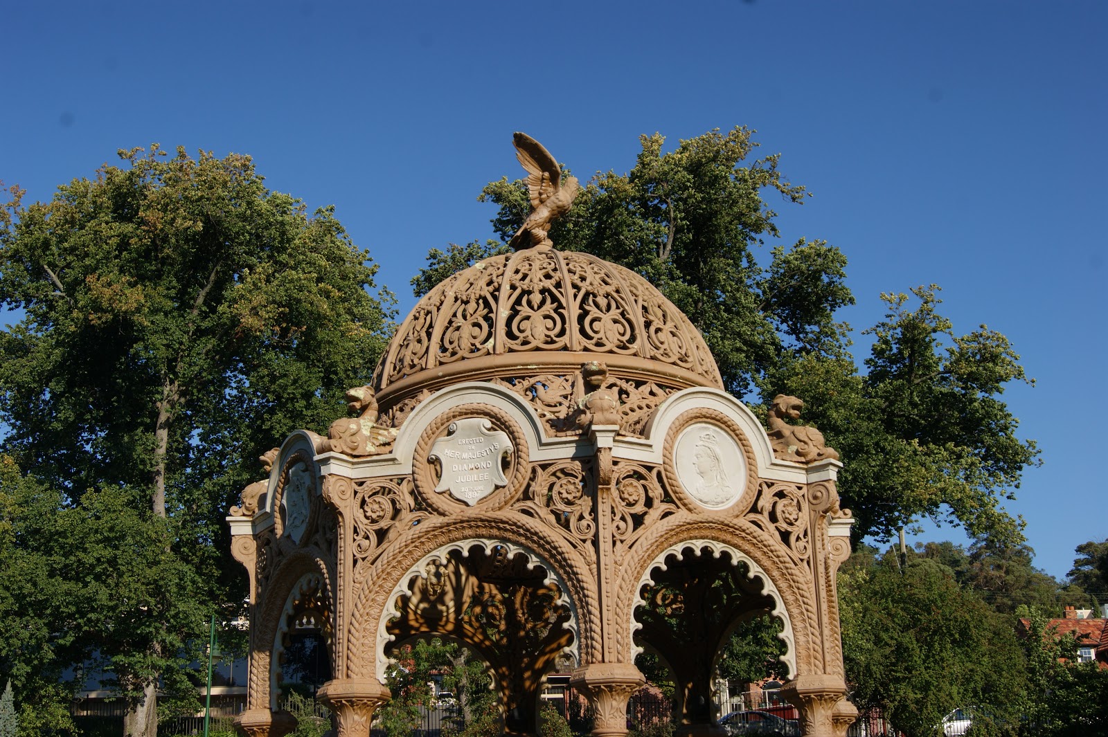
The Children’s Fountain was originally purchased in 1887 for Queen Victoria’s Golden Jubilee with the idea that it would be presented to the city by the children of Launceston. The Children’s Fountain was cast by McFarlanes in the Saracen Foundry in Scotland.

An illustration from a 1880’s catalogue shows that originally the fountain had small cups attached by chains to the central tower. The cups could be pressed against a valve stud which then released water. The catalogue subsequently promoted the benefits of public drinking fountains. “A supply of drinking water to the outdoor population and also to the lower animals, is now acknowledged as a necessity of the changed circumstances of the times and the growing intelligence of the community, encouraging habits of temperance and humanity and promoting the moral and physical improvements of the people”

However, difficulties arose when the raising of 200 pounds was required to install the fountain and as a consequence the installation was delayed. As part of the fund raising efforts and as a way of involving children, a Juvenile Industrial Exhibition was held in the nearby Albert Hall. The exhibition included examples of handwriting, plain sewing and darning and fancy work by students plus displays by a variety of manufacturers.

The fountain was finally installed outside the main gates of City Park in 1897 as part of the celebrations for Queen Victoria’s Diamond Jubilee. It stood in this position until 1908 when it was moved inside the park itself. You can still see the hexagonal pattern of bluestone blocks set into the ground outside the gates which indicates the original location of the fountain.

The fountain still stands in its 1908 location in the park, still providing the community with a source of clean, fresh water.

Main Text & Information Source –
Interpretive Sign at the Site

Historic Photo –