It took the Colonial authorities until 1835, after repeated petitions from the settlers, to begin to construct a proper road. A gang of convicts known as the Sandy Bay road party was assigned to perform the task. The convicts laboured for many years to construct the road and ended up continuing the road all the way through to Brown's River (Today's Kingston)
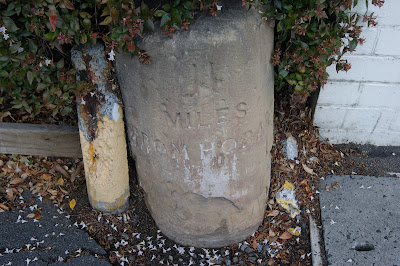
This old sanstone mile marker still survives on Sandy Bay Road and dates back to this period. It can be found on the western side of Sandy Bay Road to the south of Lambert Avenue. the inscription can still be seen on the marker and states that it is two miles to Hobart (approximately the spot where Elizabeth Street crosses over the Hobart Rivulet) from the Sandy Bay location.
An interesting sideline to the story of the construction of the road was that about 80 convicts who had been sent from Canada for participating in a rebellion against the authorities of the British colony of Upper Canada (today's Ontario) were assigned to work on the road construction in 1840. Many of them were ultimately pardoned in the late 1840's and the vast majority of them returned to North America.
A very interesting small piece of early colonial history.
Main Text & Information Source -
"The Story Of Sandy Bay - Street By Street" - Donald Howatson 2016


