Thursday, 28 March 2013

Domain House (High School Of Hobart Town)


Domain House is a grand neo-Gothic sandstone landmark built in 1848-49. It represents an important part of early colonial education as it originally began its life as the High School Of Hobart Town.
The High School was founded in 1848 by a group of leading Presbyterians and Free Churchmen, including Rev. John Lillie, Minister of St Andrews Church, Hobart. A grant of land on the Queens Domain was received from the crown and a building design was requested. The design by A. Dawson was begun in 1848 by Messrs. Cleghorn and Anderson, Builders, costing approx $3600. 

The school officially opened in 1850 and 56 boys were enrolled to commence the first term of classes. By 1851 there were already 81 pupils registered and attending classes. By 1859, boarders were being accepted and a junior school had been commenced. Dr Lillie was the first official Rector. In 1857, Rev. R.D.P. Harris was appointed Rector and remained in the position until 1885, leasing the school from the shareholders from 1862. 

The objective of the High School, as originally described, was the ‘instruction of youth in the higher branches of learning, as taught in superior classical and mathematical schools in England’, the ultimate objective being ‘to confer on Australian youth the inestimable advantages offered in European universities’. In 1885, the rights to the operation of the school were handed over to Christ College and the building was sold to the newly established University of Tasmania in 1892. It remained in the hands of the University until the main university campus was moved to its current location in Sandy Bay in 1962.

Subsequently the site became home to the Tasmanian School of Art for a period of 8 years from 1963 until 1971 when the School of Art moved to Mt Nelson and TAFE Tasmania took over the use of the building. Domain House was re-acquired, along with a number of other buildings in the precinct, by the University of Tasmania in 2011 after remaining basically vacant and unused for a large number of years and is now undergoing conservation and restoration work and will find new life as part of the University of Tasmania again into the 21st century. 

It certainly is a magnificent building that boasts an extensive history of colonial education from some of the earliest days of the colony through to the current day. It’s great to see the building being conserved and being actively utilized and available for people to visit and enjoy and not being left to rot and collapse, or have it demolished as some any of our precious historic buildings have been across the country over the years.

Tuesday, 26 March 2013

Sullivan's Cove


Sullivan’s Cove is on the River Derwent adjacent to the Hobart CBD. It was the site of initial European settlement in the area. The Cove was the initial landing site of what is now the city of Hobart
It was founded on 21 February 1804 by Lieutenant Governor David Collins, who traveled to the shore via what was then a rocky island named Hunter Island. The connection to the shore was developed and is now known as Hunter Street. The island now has a building directly above it. Although the first European settlement in the state was established further up the river at Risdon Cove by John Bowen a year earlier, that settlement was abandoned and relocated to join the Sullivan’s Cove settlers. Collins named Sullivan’s Cove after John Sullivan, Permanent Under Secretary to the Colonies. Sullivan’s Cove holds large historical and sentimental value for the city. The cove area itself is now known as Macquarie Wharf and serves as the main port for the city. Many of the original buildings along the esplanade are still standing.

Hunter St is built on the old Hobart Town causeway which once joined Hunter Island to the shores of Sullivan’s Cove. Originally the island was connected to the shore at low tide. Passengers disembarked from ships on the island then walked, waded, or were carried to foreshore. The island was the centre of the new settlement established by Governor David Collins in 1804. It was here stores were kept under guard, and in the early years it was the site of the gallows and gibbet where remains of those executed were in full view of new arrivals to the colony. Collins had a track built to the island, and roadwork excavations undertaken in 1987 uncovered footprints of adults, children and oxen, along with deep impressions of cart ruts left in the mud of the old roadway. In 1820-21 a substantial stone causeway wide enough for two carts to pass was built by convicts over the original roadway and the first warehouses, including the Drunken Admiral building, were constructed on the island to cater for the increasing number of ships docking at the harbor. Brass plaques set in the footpath today mark the route of the causeway.

Whale oil, timber, wool, wheat, flour, wattle bark, hides and meat for export were carried to ships in bullock drawn carts. In the first years of the settlement whales were plentiful in the Derwent River and by 1836 there were nine different whale oil factories employing almost 400 people. However the whales were over exploited and the industry soon collapsed. The carts also transported imported goods including plentiful supplies of rum, tea from China, spices from the East Indies, domestic and industrial products from England and luxury goods from Europe.

The present day Drunken Admiral building was constructed in 1825-26 on the northwest shore of Hunter Island, partly on reclaimed land. It was built for the Leith Australian Company which was initially established to encourage Scottish families to migrate to Australia. The company imported rum, gin, wine, ale, pork, herrings, hams, tea, coffee, mustard, stationery, saddlery, snuff, and hardware such as paint, whitening, tar, chalk, nails, implements, iron and cedar. The building was considered one of the finest in the colony, built of brick with a stone facade and roofing slate imported from Scotland, which was considered quite an extravagance at the time. 

The building included four store rooms, two offices, a sample room and a three-bedroom residence. The company’s Hobart agent, Charles McLachlan, who lived in the residence, helped establish the Hobart stock exchange and chamber of commerce, was a director of the Bank of Van Diemen’s Land, and a member of the Legislative Council. The building was later leased to Ordnance Corps for storage, and subsequently as a barracks for its officers and men. It was then used as a receiving depot and temporary accommodation for military pensioners enticed by the promise of a grant of land and a horse in return for undertaking a short term of military service each year. By 1851 it was used by the Immigration Association as a depot for new arrivals.

Advertisements of the day in Britain encouraged single women and widows of good character from 15-30 years to better their condition by emigrating. The first passengers to be housed at the depot were from the Beulah and included 12 married couples and 10 children along with 169 single women who were brought to the colony, mostly from Ireland, to work as domestic staff. The Hobart Town Advertiser of September 2, 1851 reports the ship and depot were inspected by Governor Denison and his wife who were impressed by the women and their accommodation. Domestic servants were in high demand and most soon found work.
In the 1880s the building was occupied by brothers John and James Murdoch who ran it as a flour mill and warehouse and built an additional loft. In 1923 it was acquired by Henry Jones and Co and was converted it for staff facilities with separate dining rooms for men and women. It became the Drunken Admiral Restaurant in 1978.

Running alongside the Drunken Admiral was Shades Row, a narrow passage with eight tiny cottages typical of the working class area of Wapping of which it was part. Wapping was likened to the area of the same name in London and was considered to be dirty, full of rubbish, miserable homes, drunkenness and obscenity, although research suggests its reputation was largely undeserved. However the houses were interspersed among industries such as tanneries, slaughter yards, the gas works, open sewage pits, chemical and soap factories.


The Hobart Rivulet ran behind Hunter St and was known as the Gas Works Straits. It was polluted with domestic and industrial wastes, including raw sewage and dead animals, and epidemics of diseases like cholera and typhoid swept through the community. People living in the area were mostly sailors, fishermen and laborers whose wives and daughters tried to make ends meet while the men were away by taking in washing and sewing, and going out to do domestic service. They also worked seasonally at hop picking or in the local jam factories and a few kept small shops, or pigs and poultry.

The 1987 roadwork excavations also revealed a thick layer of charcoal and the foundations of burnt buildings from the Great Fire of 1890. The fire started in Ikin’s Fruit Store and fueled by stacks of wooden crates spread to neighboring buildings. The whole of Hunter St from the Drunken Admiral down to the old gas works (next to the site of the present Federation Concert Hall) was affected by the fire. Most of the men were away and it was left to the women and children to try to save what they could, with some managing to drag a few pieces of furniture to the edge of Fishermen’s Dock. 

Firemen could do little as the lanes were too narrow for their fire-fighting equipment. At total of 22 families were left homeless. Many of the women also lost their livelihoods as their mangles and sewing machines had burned along with everything else. All but one of the horses kept in a nearby stables were saved. A mare perished when she had to be abandoned in her stall despite the brave efforts of a volunteer to blindfold her and drag her to safety. Some pets and small livestock such as chickens were also killed in the fire. After the fire homes were not rebuilt, and others were sold or demolished, and were largely replaced by commercial development, marking the end of Wapping as a residential area. 

Today Hunter St is one of the most picturesque areas of HobartFurther along is the Tasmanian School of Art, as well as several art galleries with a wide variety of artwork on display and for sale. The area also has a number of public art installations. Cruise ships anchor at the dock at the end of the street in the summer and working fishing boats still find safe harbor and add to the atmosphere of Fisherman’s Dock across the road from the Drunken Admiral.


Tuesday, 19 March 2013

Henry Jones IXL Jam Factory


Henry Jones was born on the 19th of July 1862. His parents John and Emma were originally convicts who were sent out two years apart and served their sentences separately and ended up getting married some time later. At the age of 12 young Henry Jones started work for George Peacock his first and only employer. Working six days a week, ten hours a day Henry Jones pasted labels on jam tins. At the age of 27, he purchased a share of the factory and then from these humble beginnings, rose to fame as an entrepreneur spanning five continents with interests in jam, fruit, timber, mining and shipping.


George Peacock began business in Hobart as a jam manufacturer in 1861. He bought Nos.31 and 33 Hunter Street, a pair of dilapidated warehouses in 1869, expanding to No's.27 and 29 by 1882 and a reinforced concrete warehouse was built in 1911. The fabric of the largest part of the building is of reinforced concrete and is founded on timber piles under the greater part of its area.  When it was built, the technology of reinforced concrete was quite new and this was one of the first constructions using the material in Australia. Later just before 1895, George Peacock transferred his jam making interests to Henry Jones – one of his employees.


All this originated in the buildings now comprising the Henry Jones Art Hotel. This group of buildings is located on what was once Hunter Island which was used in 1804 by Lieutenant David Collins, for landing and receiving of stores. The island was connected to the foreshore by a causeway in about 1820 and a warehouse was erected shortly after. The line of the causeway is marked by bronze markers in front of the present buildings. Because of insufficient depth and difficult docking conditions for vessels under sail, shipping transferred to the New Wharf at Salamanca Place. However, with the coming of steam, shipping returned and Hunter Island was developed with land reclamation.


Over the next forty years the premises of the Jones & Co. jam factory extended in both directions along Hunter Street. In 1903 the two warehouses next to No.33 were either substantially altered or demolished to make way for the Ice works and the Cool Store. In 1911, the remaining old warehouses at the eastern end of Hunter Street were demolished and replaced by the large concrete building now occupied by the Centre for the Arts. An article published in 1922 attributed much of the company’s success to the self-contained nature of the company as everything required by the company was produced by it, from the timber for the packing cases to the equipment necessary to manufacture the specialist machinery used in the factory. 

The old warehouses at 27-33 Hunter Street were used primarily in the production of the tin containers used for canning jam, preserved fruit and fruit pulp. The 1922 article described the tin-making operations as they were then practiced in considerable detail and discussions with past employees suggest that the processes varied little over the years.


Henry Jones and Co’s company motto ‘IXL’ dates from about 1895 and, it is said, derived from Henry’s own quote “I excel, in all the products I make”. As a brand name this motto was an inspired choice soon forming part of Tasmanian and Australian folklore. It became instantly recognizable with the man, his factories and his products. He was the largest private employer in Tasmania and at the time, the head of the largest private company in the world exporting jam to countries throughout the world. A comment in the press of the day stated “The works are comprised in a splendid block of buildings situated on the Old Wharf, including newly-erected brick premise, having 160 feet frontage by 80 feet depth, with iron roof and splendidly lighted and ventilated. 


The works were almost entirely refitted in 1898 and only the most modern and up to date machinery was now used in all departments. A new 50-horse power boiler was erected by Kennedy and Sons of Hobart, and there was another boiler of 30 horse power, the two supplying the motive power for driving all the machinery including that employed in the manufacture of packing cases, tins etc. The entire premises were constructed of stone and brick, of three storeys, with a frontage of 300 feet by a depth of about 290 feet, and a floor space of 140,000 square feet. 


In the boiling room there were seventeen large copper boilers in which the jam was made. It was said that during the fruit season, the room would be thick with steam and the air full of the fragrance of boiling fruit. The smell wafted into the city and Hobart residents might knowingly remark “Yes, it was apricot jam today”. Messrs H. Jones & Co. used no fewer than 2,000,000 tins each season, which were all made on the premises. The IXL factory employed between 150-350 workers, according to the season of the year…’


Henry Jones died in 1926 and over 5,000 mourners went to his funeral. Jam however was made through to 1979 when the factory closed down and the brand had become synonymous with quality Australian jams & preserves. The IXL business was purchased by Elders to become Elders IXL. Much of the factory area still stands in Hunter St and parts have been converted into cafés, art galleries, office space and the Henry Jones Art Hotel.


Updated 22/5/2016
Updated Information Source - www.abc.net.au - 23/7/2015

Sunday, 17 March 2013

Royal Engineers Building, Hobart


This Gothic Revival style building was constructed in 1846-47 to house the senior members of the Royal Engineers, who were responsible for arranging all works in the colony. Designer unknown, the building is of sandstone front and facings, with brick sides and rear, which were subsequently cement rendered.  An interesting feature of the building is that two of the windows on the northern side are false and appear to be windows from the outside only. The large area of Crown Land included the engineers’ parade ground, workshops, houses and, earlier, works stores, timber yard and jetty, much of which dated from John Lee Archer’s time as engineer and colonial architect from 1827 to 1838.

The Tasmanian Main Line Railway Company, which built the railway from Hobart to Western Junction (and modified the line to Launceston) from 1873 and operated it from 1876, occupied the building as its headquarters until the State Government acquired the company’s assets in 1890. The building continued as railway headquarters until the Transport Commission was established in 1938. It subsequently became the railway’s printers and stationery store.

More recently, the building was acquired by the State Government and restored with funds from Government grants, gifts from professional engineering organizations and public subscription. The building is currently leased by the Institution of Engineers, Australia, and occupied as headquarters of its Tasmania division and is situated at 2 Davey Street, Hobart, opposite the Gasworks Village area.


Friday, 8 March 2013

Ross Village


First surveyed in 1807 by Government Surveyor Charles Grimes, who traced sections of the river.  Governor Macquarie, inspired by the findings, visited in 1811 and named the area Argyle Plains and the river Macquarie. On his second journey through central Tasmania, Macquarie chose the location beside the river for a township
In 1812 a garrison of soldiers was stationed at the ford of the Macquarie River to protect the development of this future town.  Other buildings were soon built and in 1821 the settlement was proclaimed the town of Ross.  Governor Macquarie called it Ross after the home of his friend H.M. Buchanan who lived on Loch Lomond in Scotland. At that time the river was forded. Later that year a wooden bridge was built and by 1836 the stone bridge, one of the finest in Australia, was completed.  Ross was considered ideally situated being centrally located and easily accessible from both North and South.  The good flat country was ideal for farming and so for supplying food and the river provided a reliable water supply.  Indeed in those early years of the colony, the government operated a large farm in the district for agriculture and breeding of draft oxen.  It was broken up in 1830 and sold off to private landholders.

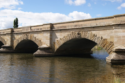
The Macquarie River was originally crossed by a ford at Ross.  In 1821 a low level bridge was built consisting of logs laid on some stone buttresses and covered with earth and gravel.  In 1836 this was replaced by the splendid sandstone bridge which is still one of the historic features of Ross today. Quite rightly the pride of the village, this beautiful stone bridge was constructed by convicts in 1836. It is the third oldest bridge still standing in Australia and is recognized as the most important convict-built bridge in the country. It was constructed on the orders of Governor Arthur and designed by John Lee Archer. 

Built by convicts its beautiful stonework is the result of two convict stonemasons - Daniel Herbert and James Colbeck. They were paid one shilling a day. Herbert, who had been transported for highway robbery in 1827, was freed after the bridge was completed and is buried in the Old Cemetery. He is credited with the beautiful carvings on the side of the bridge. Experts have described the carvings as 'possibly the richest achievement of the earlier colonial period if not the most significant sculpture on any edifice in the Commonwealth. Leslie Greener, who was largely responsible for discovering that Daniel Herbert was responsible for the carvings, has written: 'Ross Bridge is the most beautiful of its kind today. The carvings have in them that delight in the shapes themselves that our sculptors lost somewhere in the 13th century’

The military presence remained an important part of Ross for many of its early years and its influence can still be seen today.  A number of the early buildings around the town have military origins and several streets are named after battles of the Napoleonic wars.  Some of the military stationed here in those early days were veterans of these campaigns. As Ross developed it became important not only as a garrison town but also as a coach horse change and livestock market.  In 1826 it became the venue for the first agricultural show in the midlands.  These beginnings are evident in the coaching inns and the fine properties in the surrounding district.

It also became the site of one of four Female Factories opened in Tasmania and operated from 1848 – 1855. The site of the Ross Female Factory can still be visited and although very little physical architecture remains in place, it is still considered one of the most archeologically intact female convict sites in Australia.

Tasmania has an excess of beautiful and fascinating 19th century colonial towns. Places like Campbell Town and Richmond are famous for their gift shops, their pretty vistas and their overt tourist appeal. But, of all the early 19th towns, there is nothing quite the equal of Ross. The secret is that the Midland Highway (the main route between Hobart and Launceston) by-passes Ross thus preserving the original, sleepy character of the town. Tasmania was a draw card for early European settlement for several reasons. Access to the southern waters for seals and whales was one. Excellent farming districts for stock and grain to feed the rest of the colony added to the appeal to settle. The third reason, the island was ideal to send convicts to. The size allowed security of the convicts to be more manageable. 

A road was needed between the North and South of the state. White man had discovered the original aboriginal inhabitants had already carved trade routes throughout the state. One such trade route was between the Launceston district in the North and the "Hobart Town" district in the South. This trade route is now called the "Heritage Highway". The best source of labour to construct the road was convicts. The cheapest convicts to use needed less supervision, so low security convicts were used. Places like Ross were set up at river crossings along the route. The convicts could build and maintain the road and river crossing (in this case the famous convict built bridge). 

The convicts also had to build the accommodation for themselves and the officers in the village. As sandstone was more readily available than other building materials, a lasting legacy of convict built sandstone buildings now provide the visitor with an amazing experience. These early European settlers aimed at recreating a familiar environment to them. It is no mistake that the village is English in style complete with English Elms, cottage gardens and quaint Georgian style cottages.

Throughout the nineteenth century Ross was an important stopover point between Launceston and Hobart. As such it was a horse coach changing point, a town for the local garrison and an important destination for produce from the surrounding farms. The main crossroad in Ross is known, with some humour, as Temptation, Recreation, Salvation and Damnation. The reason for this combination is that on one corner (Temptation) stood the Man-O-Ross Hotel, on another corner (Salvation) was the Roman Catholic Church, on the third corner was the Town Hall (Recreation) and on the fourth stood the Jail (Damnation).  The field gun in the middle of the crossroads was actually used during the Boer War.

Today it is arguably the finest nineteenth century village in Australia. It has resisted the excesses of commercialism and the combination of the tree-lined main street, the beautiful bridge and river and the location of the Wesleyan Church at the top of the slight hill, combine to give it a remarkable aesthetic beauty and tranquility. 

The great quality of Ross is that it has not been overly corrupted by modern tourism. The town is very typically English and, with its warm Ross sandstone, is reminiscent of the towns which can be seen in the Cotswolds or in north Oxfordshire. In many ways Ross is a town which has stopped in time. It is beautifully preserved.