Wednesday, 30 October 2013

Ross Patent Slipway

Ship building has been described as the first important manufacturing industry to develop in Van Diemens Land. From an early date the merchants of Hobart Town owned or chartered ships which they used for sealing, whaling , trading with Sydney, the South Sea islands and Mauritius, and later exporting wheat, wool, livestock and timber to, other Australian colonies, and oil to Britain and China. Hobart was one of the world’s greatest whaling ports, and apart from having a sizable fleet of its own, mostly built locally, it was used by many American, French and English whalers which required repairs and provisioning. It was the whaling industry which provided the impetus for the development of the Hobart shipbuilding industry and which initially provided most of the work for the Hobart Slipyards.

Initially ships and boats were built in the bays and coves where timber used in their construction was felled. The earliest slipyards were situated on the Hobart Rivulet, and vessels were built at Sarah Island, Cygnet, Franklin, Shipwrights Point and Port Arthur in the early days of the colony.

The 1850s and 1860s saw a concentration of slipyard activity and shipbuilding at Battery Point. This included the relocation of the Ross Patent Slip from Secheron Bay to the Battery Point slipyards in 1866. The introduction of the Patent Slips arose from the need to build and slip larger vessels.
The Battery Point slipyards, like other slipyards, did not just produce and repair ships. Many associated activities such as provision of ship chandlery, coopering, sailmaking, ship design and more general engineering tasks were also carried out in the slipyards, as well as at least one fish processing operation. 

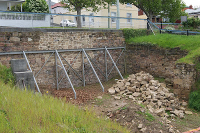
The area known as Ross Patent Slip was acquired for £800 by John Ross in 1866 when he decided to move his patent slip from its original location at Finlay Street, Battery Point. Considerable site work was required to establish the slip on the site including substantial excavation of land. The move was completed in August 1866 and the first ship slipped was the steamship Tasmania. The slip was the largest in Tasmania capable of taking a vessel of 1,250 tons. The cost of the move, reportedly £18000, meant that Ross was mortgaged to the Commercial Bank which foreclosed in 1870. After the foreclosure the slip was leased to John Lucas who used it to construct at least five ships. The Ross Patent Slip was purchased by R Kennedy and Sons in 1885. The Kennedy family were shipwrights and ironworkers who moved to Tasmania from Melbourne in 1883. The firm had established an ironworks and engineering works at Salamanca Place. They used the slip for construction and repair of iron ships. It is not surprising that a foundry and blacksmiths are reported to have been erected on the site as these would have been required for any work on an iron ship. 

At peak capacity, a technologically-advanced, steam-powered winch installed at the Ross Patent Slip had the power to manage vessels of up to 1,250 tonnes deadweight. But few ships of that size were built here - most of the slip's work was in maintenance and repair, hauling the vessels from the water in a cloud of hissing steam and billowing smoke. Ross's Patent Slip operated here from 1866 before being dismantled in 1903.
Around 1903 the slip was purchased by Harry Wood with the aim of moving the slip to a new location. Information from the archives is not clear but it seems that Wood's partners Finlayson Brothers sold the slip (or part of the site) to the Hobart Marine Board in 1914.

Some slipping was still being undertaken as Harry Moore used the slip while building the ferry Rosny and later Henry Jones IXL leased the site from the Kennedy family and had Moore construct the schooner Amelia J in 1920. It is not clear precisely when the slip went out of use.

There is a weatherboard clad toilet located centrally on the embankment to the north. It is unknown whether this relates to the slip yard operations. There is a wrought iron staircase leading from the lower ground of the former slip to the toilet.

The site of Ross’s slip demonstrates the early phase of patent slip technological development, particularly as it was one of the largest slips in its time.

Information Source:
Battery Point Conservation Management Plan, Hobart City Council, 2008

Sunday, 27 October 2013

Woodvine Farm

Woodvine Farm is situated in south-east Tasmania, about 45 kilometres east of Hobart.
In 1998 Mr Herbert Ernest Shaw donated his 377 hectare property “Woodvine” to the Crown, on the condition that it was to be made a reserve in order to protect the animals that lived there. Prior to proclamation, the property had belonged to his family since it was first settled in 1861 and was handed down to Mr Shaw on the death of his great-uncle, Edgar Long in 1977. The Woodvine Nature Reserve was subsequently proclaimed on 25 June 2001.

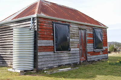
Mr Shaw had a residential license over the property and was the only person in Tasmania living in a nature reserve. Ernie Shaw died on 5 August 2005. Specifically, this site includes a small c1862 slab house converted to a shearing shed, a modern shed, grave site, c1890 cottage, blacksmith shed, outhouse, tractor shed and garage, old stables, shed by the main gates and the small shed used as a petrol store during the 1940s.

Mr Ernie Shaw’s great grandparents Daniel Long and Elizabeth Tustin married in 1861 and moved to the selection in 1862 and established a farm. They had 14 children there, 13 of whom lived to adulthood. Daniel’s father (also a Daniel) had been the licensee of the Plough and Harrow, a hotel in Sorell, from 1826. The land was selected under the Waste Lands Act of 1858. This Act introduced a policy of free selection of land before survey by small holders, up to 320 acres, in previously unsettled areas. These selectors were early pioneer families of Tasmania and it was hoped that they would clear virgin forests and help break up some of the large estates. Elizabeth was a midwife for the area and had 14 children herself, 13 of whom lived to adulthood, Oswald (born and died in 1885) is buried close to the original 1861 slab house in the enclosure under the fuchsias.

Edgar Long, son of Daniel and Elizabeth, lived on the property with two of his sisters Mary and Ella who together brought up his grand nephew Ernie Shaw. The farm income was derived primarily from wool and from the orchards grown in the vicinity of the farm buildings. The complex of farm buildings including three dwellings and a (collapsed) blacksmith’s shop has the potential to yield a great deal of information about the lives of early settlers.

The earliest building in this complex is the original small slab house c.1862 with a hipped shingled roof and an extension at one end. It had been converted into a shearing shed.

Adjacent to it is a slab blacksmith's shop with a shingled gable roof and a stone forge.

The older c1890 timber cottage had not been used for 50 years except for shearers, but was full of movable items from a device for getting iron tyres off carts, to a boot last and a yoke that was used to carry 2 buckets of water from the creek. It was taken over by the repatriation hospital for returned soldiers during the First World War.

The main cottage was erected in 1902 and was Mr Shaw’s home until 2003 when he left Woodvine due to health issues. They had no bath, tanks or inside toilet, and the outside toilet was 50 metres away. The chimneys were painted with pipeclay using brushes made from cut grass. Electricity was not connected until 1983, and by that time Ernie was the sole occupant. Before this, kerosene lamps, candles and a fuel stove were used and the cooking was done on the open fire in saucepans and a kettle.

A brick outdoor oven was used until about 1965. "If you couldn't hold your hand in the oven while you counted to thirty, it was too hot. When it was raining you would have to hold an umbrella in one hand while cooking at the oven" (Ernie Shaw quoted in The Sunday Tasmanian, 26-8-2001).

The buildings are constructed mostly of timber with various degrees of deterioration evident and major structural work required on some. A number of the buildings have been propped or had other work undertaken to maintain them. The land, unlike most of the surrounding properties, had relatively low levels of clearing and very low levels of grazing. While many of the buildings display fine examples of bush carpentry and innovation to extend the useful life of the buildings, some of the buildings cannot easily be repaired as the timber footings and supporting poles are rotten or rotting. This has made stabilization of these buildings difficult and costly and as a result, several of the buildings have collapsed in recent years.

There are timber fences remaining throughout the reserve which demonstrate early construction techniques. Most of the portable cultural heritage items have been placed in safe storage including larger items of farm machinery, some remaining in the reserve and an extensive inventory reveals an outstanding collection of personal effects and memorabilia from several generations of the families who lived at the Woodvine property. The appeal and strength of the collection lies with the depth of information it provides about one of the State’s pioneering farming families; their longevity on the Woodvine property and within the district; and their ‘make-do’ philosophy.

Woodvine is a farm complex which was owned by several generations of predominantly unmarried members of the same family, living in a manner that reflected their forebears and resulted in a unique cultural snapshot of a depression era family with material assets of both built structures and movable items connected with the running of a primarily self-sufficient and isolated farm.

Woodvine is an artifact of continuous human occupation and as the site was complete with machinery, hand tools, household items and photographs, it is therefore, a time-capsule of how life used to be in Victorian and Federation Tasmania. It’s as if the owners only walked away yesterday.

It is a wonderfully serene place to visit and one can almost feel the presence of old farmers going about their daily business in these idyllic surroundings.

Information Source:
Woodvine Nature Reserve Management Plan 2010
Tasmanian Parks & Wildlife Service

Wednesday, 23 October 2013

Beaulieu Homestead

Beaulieu is one of the oldest buildings in the New Town area, dating from the late 1820s.
Henry James Emmett arrived in Van Diemen's Land in November 1819 and held various middle-ranking positions in the colonial administration.   In the late 1820s Emmett built Beaulieu (originally known as Beauly Lodge) and lived there with his wife and nine children.

Unfortunately, with the erection of his house, Emmett's fortunes declined. Unable to cope with building expenses, he temporarily borrowed the fees collected by his office. When they fell into arrears, a board of inquiry ordered him to repay them fortnightly and furnish regular accounts, but exonerated him from deliberate dishonesty. As his financial troubles increased, his requests for a larger salary became more urgent, but the presumptive nature of his pleas for improved status, including appointment to the Commission of the Peace and a retiring allowance of land, met with blunt refusal. However, in 1833 he was appointed clerk of the peace and registrar of the Court of Requests, a title he considered of greater prestige than that of chief clerk. His financial embarrassment continued and he resorted again to the public purse, this time borrowing from wine and spirit licences which he had collected although he knew they were not his responsibility. Dismissed from office, he set up as a general agent, amanuensis, and debt collector and appealed unsuccessfully to the Colonial Office. Beaulieu was advertised for sale in the Colonial Times newspaper in May 1833.  The notice describes 'the house, containing an elegant entrance hall 16 ft. by 8 ft., an elegant saloon 24 ft. by 16 ft., a comfortable dining-room 20 ft. by 16 ft., all communicating by folding doors, and opening by French windows into a tasty veranda.  There are five bed-rooms, corresponding in size and proportion to the others, a good kitchen, laundry, butlers' pantry, secure store-room and dairy. The out-offices embrace servants' rooms, good stables, coach-house with lofts and granaries, poultry house and yard, dove cot, and an extensive range of useful buildings. There are three acres of land encircling the house, laid out with much taste, and covered with English grasses.'

Beaulieu wasn't sold and was advertised again in November 1833 when it was described as a 'delightful residence for a family of the highest respectability'.  Beaulieu was purchased by George Bilton, a merchant who operated from premises at Old Wharf in Hobart.  Bilton only lived at Beaulieu for a few years before advertising it for sale in The Hobart Town Courier newspaper in December 1837.  The property was described as a 'beautiful residence … commanding one of the finest views in the island.'
John Swan purchased Beaulieu and 13 acres for ₤3,000.  Swan had arrived in Van Diemen's Land in 1823 and had established a successful store in Hobart.  Swan purchased some of the surrounding land so that the estate extended to some 100 acres and became known as 'Swan's Hill'.  Swan lived at Beaulieu with his large family and two of his daughters married men that were to become prominent politicians - Catherine married Thomas Daniel Chapman and they lived at Sunnyside (today's 7 Swanston Street, New Town), and Maria married William Nairn and they lived at Leyton (today's 36A Augusta Road, New Town).  John Swan died in 1858 but the Swan family continued to own Beaulieu until it was sold to Russell Young in November 1875.

Russell Young was a solicitor with the firm, Russell Young and Butler, and he helped to found the Southern Law Society.  Young was a member of the House of Assembly between 1872 and 1877.  Young also served on the committee of the Southern Tasmanian Agricultural and Pastoral Society and won prizes for his livestock at shows that were held in the grounds of Hobartville (today's Friends' High School), located on the opposite side of New Town Road from Beaulieu.  Young was an excellent amateur photographer and his photos are now part of the Tasmanian Museum and Art Gallery collection, an institution that he was largely responsible for founding.

Henry Robert Brent moved into Beaulieu in 1883 and lived there until the early 1920s.  Henry was the son of John Brent who co-founded the successful auctioneering business, Brent and Westbrook.  In the 1870s, Henry became a salesman for Roberts and Co, and later became one of the company's directors.
The Beaulieu estate was about 10 acres at this time and the homestead had extensive gardens, including a large croquet lawn.  The Brent family gradually subdivided the Beaulieu estate during the 1910s and 1920s.  The Church of England purchased a block of land fronting New Town Road and St James' Church was built in 1916.  Rupert Avenue, which was named after Henry Brent's eldest son, was constructed in 1920.
The Beaulieu homestead was purchased by William James Taylor in 1927 and it remained in Taylor family ownership until at least the 1950s.  Beaulieu still had tennis courts at that time but units were built at the rear of the property in the 1970s. Beaulieu is in wonderful condition and is currently a private residence.

Information Sources: Australian Heritage Database
&
Australian Dictionary Of Biography: Henry James Emmett (1783 - 1848)

Sunday, 20 October 2013

Orford

The original inhabitants of the area were the Tasmanian Aboriginal people from the Oyster Bay tribe who lived a peaceful hunter-gatherer lifestyle. Following European settlement, many died from introduced disease, displacement from their native home or conflict with settlers.
During the Black Line wars of 1830, Edward Atkyns Walpole captured a man and a boy and was granted 1000 acres south of the Prosser River. He named his grant “Strawberry Hill” in honour of the London home of Horace Walpole, 4th Earl of Orford.

In 1837, Walpole sold his land and the area was recorded as Orford, a Post Office Town. Early settlers managed farms, were fisherman or worked in the local timber industry with very basic infrastructure around them.

The town was first established as a mainland port for the convict settlement on Maria Island. However, the marine infrastructure never consisted of more than a few short jetties in shallow waters just inside the mouth of the river which still remain today. The narrow channel at the river's mouth is flanked by a substantial sandbar, rendering the river unsuitable for larger vessels. The main source of supplies were shipped by steam vessel or small trading vessels because the road to Hobart on the south bank of the Prosser River was reported to be one of the worst tracks in the colony. It was sarcastically named “Paradise Gorge”. The Prosser River was named after Thomas Prosser, an escaped convict, who escaped in 1808 and was recaptured in the area.

In 1844, convicts started work on what is known as the “Convict Road” on the north side of the river and built the Paradise Probation station to house the convicts during construction of the road. Three years later, work ceased and the station was abandoned. Most of the buildings were destroyed by a bushfire in 1856 although a few remains can still be seen along the walking track.

By 1861, improvements were made on the south side of the river to the road and a punt began operating across the river until it was replaced by the Meredith River bridge in 1866 and further two bridges since.
From 1869, a small community grew up around a quarry near east Shelley beach. The quarried sandstone was used in buildings in Hobart and also in the construction of Melbourne’s Post office & Town Hall. With the closure of the quarry in 1882, many people left the area although Orford remained popular with campers from Hobart and nearby districts.

In the early 1900’s, Orford became known as a pleasant holiday resort with several boarding houses and holiday shacks dotting the landscape. Since the dam was completed on the Prosser River, more permanent homes and holiday houses have been built, existing infrastructures such as shops and the school have been improved and new recreational ventures commenced.

Residents and visitors continue to enjoy the river, beaches and many activities this peaceful area offers including walking the various tracks along the beautiful coastline.

Information sourced from local history signs around the Orford area

Sunday, 13 October 2013

Cleveland Union Chapel

Cleveland was once an important coaching station and convict road station. The convict station was built in 1839 as a serving station to repair road and could accommodate 100 prisoners at a time. After 1842 it became a hiring depot for labour and by 1847 there were 23 convicts billeted there on a regular basis.

Cleveland was originally planned as a large town. Plans were drawn up and streets laid out and named but a lack of a constant supply of clean drinking water put a stop to the idea. The plans of the town can be seen at the St Andrews Inn. Between the 1850s and 1870s, there were two main coaching inns in Cleveland, St Andrews Inn and The Bald Stag Inn.

By the early 1850s, there was a need for a local church in the town. By 1855, James and David Gibson had constructed a neat little brick church that originally measured only 22 ft 6 inches by 17 ft.

An unusual feature of the building was that it only had windows down one side of the building. The building was originally used by the Presbyterian faith as their centre of worship. The building was eventually lengthened to 31 ft long. It was later used by the Anglican Church as its local centre and according to the signs at the site, they continue to use the chapel for services. Press reports from the period show that in January 1869, a juvenile bazaar was held at the Esk Vale woolsheds in order to raise funds for repairs to be undertaken on the little church.

The building is set back from the Midland Highway and appears to be in the middle of a paddock. However, it is easily visible and accessible from the roadway. With its small graveyard in front of it, and surrounded by a small wire fence and a small entry gate, the chapel is easily accessible and you can walk around the graveyard and the front of the building and get up close.

Information Source: Information Signs posted around the site by Cleveland Progress Association.